People-friendly streets in St Peter’s
In July 2020, as part of our people-friendly streets programme, we introduced a low traffic neighbourhood trial in St Peter’s.
Like many neighbourhoods within the borough, St Peter’s has suffered from increased traffic volumes in recent years from the use of the area as a short-cut.
The trial aimed to:
- Make it easier and safer to walk and cycle
- Clean up the air we breathe
- Reduce road danger
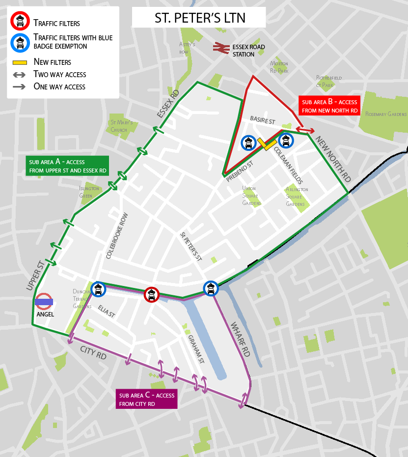
We introduced the following traffic filters: Colebrook Row, Danbury Street, Coleman Fields and Wharf Road, with a traffic filter and bus gate on Prebend Street.
You can see locations of the filters on Google maps or view the map of the St Peter's low traffic neighbourhood (LTN) at the bottom of the page. A downloadable version of the map is available in the 'Useful Documents' section of this page.
Next steps for St Peter's
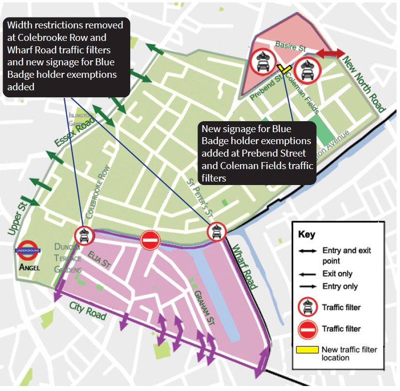
In December 2021 we announced that we would be continuing the St Peter’s PFS neighbourhood and made an important change to allow Blue Badge holders to travel through the traffic filters.
We also removed the width restriction at Colebrook Row and Wharf Road, installing planters and new signs to make the Blue Badge holder exemption clear.
We have decided to continue the St Peter’s PFS neighbourhood with the Blue Badge holder’s exemption on a permanent basis from 11 November 2022.
Since December 2021, we have continued to monitor the St Peter’s PFS neighbourhood. The final monitoring results compared data collected in June 2020 and 2021 with data collected in July and September 2022 to monitor the scheme after we exempted eligible Blue Badge holders.
The results demonstrate that the St Peter’s PFS neighbourhood is continuing to have positive impacts.
You can find information on previous monitoring data and the results from the public consultation held in September 2021 further down this webpage.
The future of St Peter's
We will continue to work to improve the local environment in St Peter’s, including:
- People-friendly pavements: we will make improvements to footpaths to ensure they are accessible for walking, wheeling and using buggies and wheelchairs. By the end of this year, we will be improving the footpath at Popham Street.
- Greening: we will work to implement more greening like the planters recently put in at New North Road.
- Traffic: we will continue to work with TfL on lifting banned turns at the Essex Road and New North Road junction and delivering improvements to Greenman Street.
- Charlton Place: following public consultation, we are continuing to work on plans to deliver improvements to Charlton Place, including traffic reduction measures, greening and pavement improvements.
- Safety: We will continue to monitor local roads and address safety concerns at main road junctions, exploring options for further measures.
Monitoring
We have published our most recent monitoring report for the St Peter's people-friendly streets neighbourhood. This report includes data collected in June 2020 and 2021 with data collected in July and September 2022 to monitor the scheme after we exempted eligible Blue Badge holders.
We published our pre-consultation monitoring report for the St Peter's trial area in September 2021. This report includes data one year on from the launch of the people-friendly streets trial in July 2020.
We published the interim monitoring report for St Peter’s, in February 2021.
Consultation
We held a public consultation on the St Peter's people-friendly streets neighbourhood from 13 September 2021 to 11 October 2021.
We published our pre-consultation engagement results report for St Peter’s in December 2021. This report includes all feedback up until the public consultation (13 September 2021 – 11 October 2021) from Commonplace and Trial feedback surveys, email correspondence, formal objections and stakeholder meetings.
We published our independently written consultation report for St Peter’s in December 2021. This report includes feedback received through the public consultation (13 September 2021 – 11 October 2021).
You can find a summary of the findings from the consultation on the dedicated consultation webpage.
Map of the St Peter's low traffic neighbourhood

Download the St Peter's LTN map
Useful documents
-
St Peter's LTN map

(png, 152 KB)
-
St Peter's LTN permanent DDR
(pdf, 1 MB)
-
St Peter's LTN permanent EQIA (Appendix 5)
(pdf, 6 MB)
-
St Peters Monitoring Report (appendix 4a)
(pdf, 1 MB)
-
St Peter's Monitoring Report Appendix (appendix 4b)
(pdf, 1 MB)
-
St Peter's next steps and future improvements leaflet (appendix 2)
(pdf, 1 MB)
-
Objections table for St Peter's (appendix 5)
(pdf, 112 KB)
-
Appendix 6 St Peter's Consultation Analysis Report - Steer
(pdf, 2 MB)
-
Appendix 5 St Peter's pre-consultation and engagement report
(pdf, 2 MB)
-
Appendix 4 St Peter's ETO changes EqIA
(pdf, 306 KB)
-
Appendix 3 St Peter's Leaflet to residents
(pdf, 560 KB)
-
Appendix 2c St Peter's Street Wharf Road
(pdf, 757 KB)
-
Appendix 2b Prebend Street and Coleman Fields
(pdf, 674 KB)
-
Appendix 2a Colebrooke Row
(pdf, 334 KB)
-
Appendix 1 Location map of proposed changes
(jpg, 160 KB)
-
St Peter's ETO changes DDR
(pdf, 335 KB)
-
Appendix 7 responses to objections
(pdf, 1 MB)
-
St Peter's people-friendly streets pre-consultation monitoring report
(pdf, 4 MB)
-
St Peter's people-friendly streets Interim monitoring report
(pdf, 4 MB)
-
St Peter's changes June 2021 Resident Impact Assessment
(pdf, 273 KB)
-
St Peter's PFS LTN changes leaflet
(pdf, 1 MB)
-
St Peter's Resident Impact Assessment for people-friendly streets
(pdf, 528 KB)
-
St Peter's Delegated Decision Report for people-friendly streets
(pdf, 541 KB)
-
St Peter's detailed information
(pdf, 647 KB)